Environmental Research and Education Center

Environmental Research and Education Center
The project stems from the restructuring of the UPZ (Unidad de Planeamiento Zonal) of Tintal Sur in the locality of Bosa. It is decided to propose a new partial plan in the area, which is situated on the outskirts of the city of Bogotá, along with a network of
facilities that aim to rehabilitate the area environmentally and also restore the Chiguasuque Wetland / La Isla, which is currently missing, thus creating an environmental focal point.
Location
Bogota - Colombia
Bosa - San Bernardino XXII
Area
Estim. 2,500 m2
Year
2021
WorkGroup
Diego Alejandro Herrera
Category
Urban Equipment
Instructors in charge
Néstor Iván Gualteros - Carlos Alberto Vanegas - Edilsa Rojas Sanchez - Fabio Andrés Ferroni Del Valle - Marcela De La Roche Merino - Jesús Guillermo Diaz Escobar
.png)
.png)
.png)
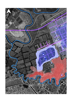
The identification of urban, environmental, social, and technological problems is carried out in the UPZ (Unidad de Planeamiento Zonal) of Tintal Sur. It is found that this UPZ houses two of the most important rivers in the city of Bogotá, namely the Tunjuelo River and the Bogotá River, as well as the deteriorated and missing La Isla Wetland.
In the UPZ of Tintal Sur, a problem of disconnection from the city of Bogotá is identified. This is because the UPZ belongs to one of the outskirts of the city, and as a result, the district's involvement is limited to proposing a minimum number of mobility and transportation strategies. These strategies mainly allow transporting residents from the UPZ to the city centers, without bringing city residents to this area. Additionally, the lack of significance in the area contributes to this segregation.
Based on the problems and weaknesses of the area, the diagnostic phrase "social and economic segregation due to morphological disconnection" is established. From this diagnosis, a hypothesis is formulated: to create a node that adds weight to the sector, giving it significance and enhancing the city's potential.
.png)
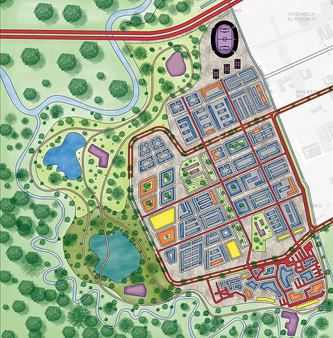
Implantation Site
With the network of facilities established in the new partial plan, the location for designing the project is strategically chosen.

Analysis
Once the implantation site is established, an analysis of the location is conducted to determine factors that contribute to the design or need to be taken into account during the design process


Vehicle and Pedestrian Axes
Ecological Structure

Network of Water Bodies

Educational Centers
Formal Process
Based on the site analysis, the decision is made to play with pedestrian axes connecting to the educational center and the vehicular axes. Three strategies are proposed for the project:
-
Fluid circulation, allowing a direct relationship between the urban and environmental aspects, completely avoiding barriers that divide the project and the city.
-
Permeability of the facilities towards the park and the city, with the primary goal of a direct interaction between the park and the facilities, creating a mutual exchange.
-
Establish a connection with nearby facilities (schools) to promote more interaction with the facilities and generate increased activity in the area.

In alignment with the axes, the decision is made to create a grid, ensuring adherence to these axes and providing a sense of form.

The shape of the project originates from extracting a rectangle from the grid, which transforms into a cube, thereby establishing the form of the spaces.


The rectangular cubes are placed along the grid, initiating what would be the form of the project.

As it became too invasive, not allowing passage and creating a barrier between nature and the urban environment, the decision is made to play with levels and voids in the project. This creates permeability in the project to avoid restricting the place with a wall.

A system of steel beams and columns is established as the project's structural framework. This is done with the purpose of creating visibility for the project from different perspectives.


Environmental Guide
An environmental guide is presented for the project, proposing a water management system through rainwater collection, which undergoes a process for garden irrigation. Additionally, a water purification system is introduced. The guide also outlines an air management strategy, incorporating a landscaping design that creates a barrier to prevent polluted air from entering the project. Furthermore, the proposal includes the use of new technologies, such as habitable roofs that generate vertical gardens within the project. Waste management is addressed through an organic waste recycling system, serving as nourishment for the gardens.
CONSTRUCTIVE DETAILS


FLOOR PLANS


MULTIMEDIA


Go Back Up